DCDB Upgrade Project, Mount Isa
Client
Mount Isa City Council

CadCon were recently requested to undertake a project to supply a spatially accurate digital cadastre for the Mount Isa City Council. Council made this request because of the following benefits a spatially accurate digital cadastre provides:
Spatially accurate boundaries in a digital cadastre significantly enhance the value of aerial photography:
- Fences line up with boundaries;
- Encroachments become apparent;
- Preliminary design work can be undertaken without the need for survey.
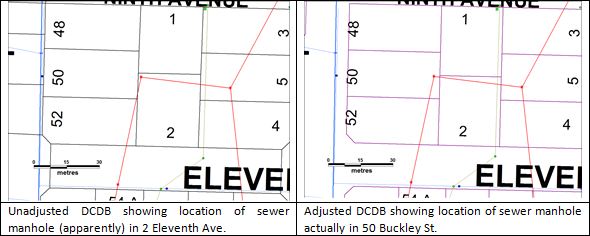
Value is added to existing asset mapping systems through an improved ability to make accurate maintenance and design decisions.
The completed data set is provided to both Council and the DNR&M. This means future maintenance is undertaken by DNR&M and new survey plans fit seamlessly into the data set.